


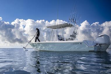
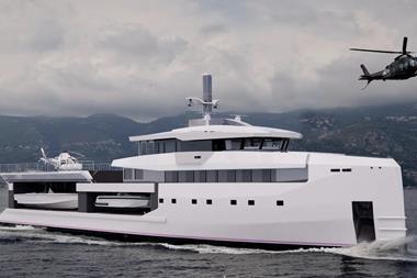
With technology evolving from the autonomous shipping sector, boat owners can now delegate much of their navigation to a tireless, all-seeing watchkeeper
In this section
- Autonomous tech
- More power
- Interfacing e-drives
- Customisation ECDIS and e-charts
- Installer’s view
- Movers & Shakers
Talk to the main suppliers of marine navigation electronics, and the trends appear to be consistent. Customers are seeking more processing power, much sharper graphics, wider screens and ‘phone-like’ ease of use. Two more trends are also coming to the fore. Greater connectivity, allowing a host of portable devices, including smartwatches, to connect seamlessly with the boat’s systems, and the use of artificial intelligence (AI) to help interpret the data.
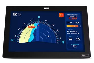
Another rising trend is the use of cameras, some operating beyond the visual spectrum. High-quality (4K) video cameras are being supplemented with thermal imaging and infrared ‘night vision’ capabilities, with the images compiled and presented as clear, real-time video with overlaid graphics.
“The use of camera systems on boats is becoming very popular,” says Raymarine’s sales manager (UK) Richard Marsden. “Customers want to be able to see all round their boat as they dock, and to recognise objects on passage, especially at night. Our FLIR thermal imaging cameras, and our NeuDock system developed from autonomous shipping, are both in demand, especially to the owners of large yachts and catamarans. The system adds a new dimension to the boating experience. Owners also see it as an investment against a costly repair bill should a hazard go undetected, or a docking go wrong due to avoidable blind spots.”
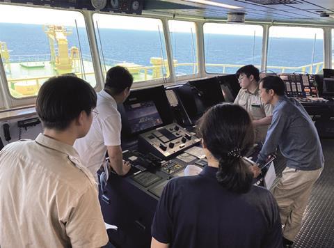
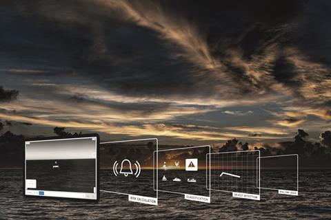
Tech from autonomous shipping
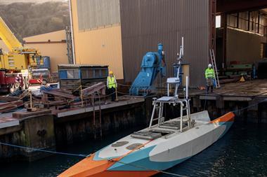
Whilst human beings can make excellent pilots and navigators, they still need all the help they can get. Electronics such as radar (RAdio Detection And Ranging), Sonar (SOund Navigation And Ranging) and AIS (Automatic Identification System) have made a huge contribution to safe passage-making, but machine learning (a form of AI) is adding a whole new dimension. Much of this technology is filtering down from the burgeoning shipping industry, which is harnessing autonomy across the whole sector, from quayside loading to deepocean routing. Taking the crew out of the equation is seen as a major boost to efficiency, not just in salaries but also with increased safety. With no humans aboard you eliminate human error, in theory, anyway.
Robot ships can also operate in a pandemic, with no crew to act as vectors for disease, whilst the use of ‘big data’ for engine efficiency and automatic weather routing can reduce fuel consumption by several tonnes per voyage. Fully autonomous ‘robot’ ships are already in the final stages of testing and are proving remarkably adept. As a result, some leisure craft makers are also experimenting with autonomy, mainly so a crew of complete novices can always be brought safely home. Some boats will even self-dock, not exactly a novelty in a world of self-parking cars, but impressive when you consider the extra challenges of wind, waves and current. However, enabling ships and leisure craft to be fully autonomous requires a very high level of sensory perception. The vessels must not just be able to ‘see’ extremely well in all weather conditions, they must also be able to make the right decisions when the unexpected occurs.
More power
All this advanced technology is requiring a lot more electrical power, although OEMs are at pains to keep consumption to a minimum. “We noticed a lot of upgrading during the pandemic,” says installation specialist Chris Rankmore of Platinum Marine. “People were outfitting their boats with more powerful equipment and 5G systems so they could spend longer periods on board and continue working remotely. Many found the prices of quayside electricity to be very steep, so instead opted for a lot more onboard power generation, especially from solar. With CANbus systems like EmpireBus and CZone, the boat is never completely ‘off’ when unattended. Even though the draw of monitoring systems is very low, the batteries need more regular topping up, so renewables are proving very popular, even on motorboats.”
Incidentally, the greater electrification of the average boat, with many doggedly connected to shorepower to maintain the batteries, has also increased the galvanic action in harbours and marinas. More stray current leaking into the water has led to some problems with damaged stern gear and other underwater fittings, requiring greater attention to preventative measures.
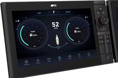
Better MFDs
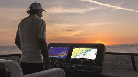
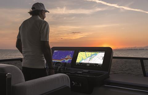
Critical to the interpretation of all the sensory data is the Multi-Function Display (MFD). Just as with the modern car, this flat, usually touch-sensitive screen has become the heart of the dashboard, where all system control is focused. The waterproof and sun-viewable displays allow high-definition images to be seen from any angle, even through polarised sunglasses. (Earlier screens would appear black if viewed this way). As a result, digital radars can offer crisp, colour-coded images. Logarithms interpret the mass of returns so the navigator knows exactly what they are seeing. On Furono’s FR-10 and 12 models, for example, rain squalls are shown as a mass of blue dots, whilst a vessel that could prove a problem is painted red. Sonar can now present a three-dimensional picture of the seabed ahead of the vessel in vibrant colours, with returns so precise that you can make out the details of a wreck. On Simrad’s Structuremap software, additional information about which wreck you are seeing can be added to the display with charting overlays. Meanwhile, AIS can write infographics over realtime video of the area being scanned, as witnessed on Raymarine’s Axiom displays.
All this functionality has evolved from CANbus (Controller Area Network) technology. This allows a multitude of devices to operate collectively without competing and uses a single cable to control dozens of digital switches. For leisure marine, the global standard was set by the US-based National Marine Electronics Association (NMEA) starting in 1983 with NMEA0183, v1.00. Retaining the launch date in the acronym, NMEA2000 is now the industry standard, achieving that status in 2009. Such has been the success of this communications protocol, backwards compatible with 0183 via low-cost gateways, that other off-road industries are seeking its adoption. One is the agricultural sector, where each OEM currently has its own proprietary protocol, trapping customers into brand loyalty by default. Farmers look at the marine NMEA2000 with a certain degree of envy.
To see what the OEM and end-user can expect in the years ahead, and to explore the sustainability of the electronics industry, IBI has approached key OEMs to discover trends and new products. We have also spoken to various installers to see just how smart our boats are likely to get. How close are we to letting the electronics make all the decisions, and we just go along for the ride? Closer than we think, it seems.
Interfacing electric drives
With an increasing number of boatbuilders now offering electric propulsion, many in the high-voltage bracket (90V-800V), the roll-out is already influencing navigation electronics.
“Almost monthly we get a new company launching an electric boat, which is great, and we support them as best we can,” says Garmin’s Dave Dunn. “Part of our testing is for electrical interference, but so far we’ve had no issues. The infographics required are not directly resident on our plotters, but through our EmpireBus line, we can monitor and customise the data. The beauty of the MFD today is it is more of a command centre, so whatever you plug into it, we can make it look and do almost anything you want it to do. We have partnered with several electric boat companies to show their data, such as voltage, rate of charge, and potential range.”
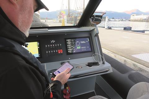
A major OEM in electric propulsion is the Norwegian company Evoy, which has developed a comprehensive software package for the monitoring and control of their high-output (150hp-400hp) motors. These have been linked to navigational data to give precise range information and recharge times.
Spearheading Evoy’s user interface is Kjetil Watnedal, the company’s chief digital officer. IBI was given a practical demonstration in Fløro, Norway, of the system he has helped devise.
“We have chosen to display a custom user interface on a generic MFD/chart plotter, as opposed to having our own separate screen,” Watnedal explains. “The MFD already supports compatible navigation solutions, so we don’t need to spend resources on our own hardware. Currently, we are compatible with the NextFour QExperience MFDs, and support for Raymarine Axiom MFDs is now under testing. Going forward, we will likely extend support to Garmin and Simrad as well. The technology we are using is generic and supported by most of the big MFD vendors, and the custom Evoy user interface will work a bit like an app on the screen.”
Watnedal says that Evoy’s ebrain is running the user interface ‘host’, and the MFD only works as a ‘client’, showing the user the app. By using NMEA2000, the MFDs will get all the information they need, so that chart overlays will work in addition to the custom Evoy interface.
“As of now, the generic MFDs are not great at supporting electric propulsion,” Watnedal says. “Some vendors, like Raymarine and Nextfour, are now starting to support the electric PGNs (Parameter Data Groups) for NMEA2000. That will make support much better.
“Meanwhile, we have chosen to create our own separate custom user interface to give the user a modern, intuitive and assuring experience. They can check the charge status before using the boat (with the Evoy app), when underway to determine range, when charging, and after they have used the boat to monitor its status (again with the Evoy App).”
Watnedal feels that even though the MFD suppliers are getting better at creating user interfaces, the experience is still not on par with the automotive industry.
“We think we can do a better job than the generic MFD suppliers,” he says. “We do this by having direct communication and control with our motor system, as well as knowing what is important to the user. This will create an ‘intuitive and perfectly integrated solution’, which is a key branding phrase for us.
“We want to make more advanced functionality around range, including a chart graphic, the most efficient speed to maximise range, and advanced trip planning including charging locations.”
Futureproofing the MFD
There has been a trend for some boat owners to baulk at the price of an MFD, and instead try to utilise one of their existing portable devices instead, such as a phone or laptop, but the trend seems to be fading. Instead, phone or tablet apps are being used for remote access, with the MFD increasingly being installed as the primary navigation aid.
“There was a trend a few years ago to use tablets for navigation, but the problem was durability,” confirms Garmin’s Dave Dunn. “The screens are not sunlight readable, nor particularly waterproof, whereas MFD screen costs have dramatically come down. You can buy a dedicated marine screen now for a lot less than even five years ago. Another factor is what happens if a boater loses or damages their device? They can no longer navigate by app, which could present them with a major problem. There are still people who like to use tablets or mobile devices with navigation apps, but usually in a supportive role.”

Speaking for Raymarine, Richard Marsden was keen to point out just how much testing goes into a new MFD product. “At our test centre in the UK, we do all manner of things to a new model,” he says. “We knock them about, expose them to saltwater and extremes of temperature, and put them through the equivalent of many years’ use in tough conditions. We know it will be as rugged and dependable as they come.”
The average changeout time for equipment is between 10-15 years, with boaters less brand loyal than they used to be. Getting another 10 years from a new suite of instruments depends largely on futureproofing.
“We use that term a lot,” says Garmin’s Dave Dunn. “It’s part of our DNA. We want cutting-edge technology, but we don’t want to leave the customer behind, and that is a delicate balance to achieve. The equipment we are selling is a big investment for a buyer. So when we build a product, especially MFDs or plotters, we overbuild them with extra memory and processing power, so they can be more futureproof. For example, the GPSMAP 8600 series has been out for over five years now, but with free software updates a unit from 2019 will perform as if you bought it today. You get the same features and tech as current units. Taking things a step further, our GPSMAP 9000 series, launched last year, is our premium product. It has a choice of larger screens, a 4K display, and seven times faster processing. That’s the future. We also built the infrastructure so if you have a legacy Garmin system on your boat, you can still use it via a gateway. You don’t have to start at ground zero.”
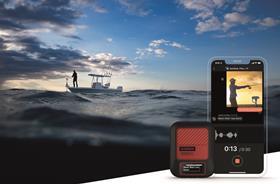
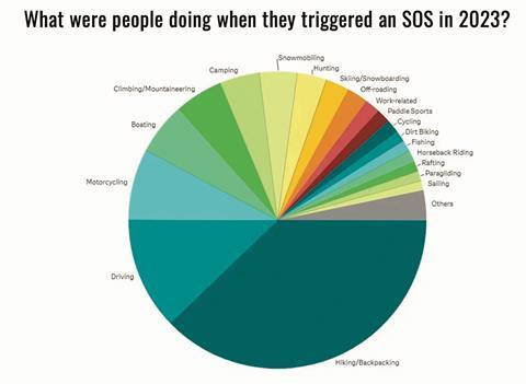
For the millions of small craft that simply don’t have room for more than a small navigation unit, Garmin’s latest InReach device offers connectivity from even the remotest regions on earth. The InReach satellite communicator from Garmin has been around for a while and had useful but limited capacity.
The idea was to keep it as simple as possible and use low earth orbit (LEO) satellites to send and receive position reports and a few words of text. The latest version, however, the InReach Messenger Plus, is designed as a satellite communicator, expanding users’ ability to stay in touch beyond cell service. Users can send global two-way texts of up to 1,600 characters, but also send photos, which could help with medical emergencies by showing responders the exact nature of a problem.
Designed for all outdoor users, including marine, the case is waterproof to IPx7 (30 minutes submerged to 1m) and has a rechargeable battery that can last for weeks on standby. The device uses the Iridium satellite network to give pole-to-pole coverage and includes voice messaging via the SOS function. Prices will start at US$499 for the basic unit with satellite subscriptions from $14.99 a month.
The trend for some boat owners to use a phone or laptop as a primary navigation device seems to be fading
Customising equipment
With branding almost disappearing from the frames of displays, or just very subtle, like Raymarine’s tiny R-logo, full customisation is instead being reserved for the graphics themselves. OEMs are now able to work with Raymarine on bespoke digital switching solutions when installing the YachtSense system, enabling them to add their own graphics to a display, with the name of the brand and any corporate colours included.
Where customisation is prevented is on the colours of charts of radar displays. Instead, a degree of global standardisation is being sought (See panel).
A recent addition to the OEMs customisable portfolio is the MConnect from US-based Maretron. MConnect is described as a “cutting-edge, NMEA2000-certified web server and screen editor designed to enhance the boating experience by centralising control, monitoring, and automation functions. It connects to over 400 NMEA2000 data points on a vessel, providing real-time visual feedback through customisable, modern graphics on multifunction displays or any browser-enabled device.”
MConnect has been designed with boatbuilders in mind, allowing them to stamp their specific logos, colours and graphics over the interface to ensure their products stand out when the MFD fires up. Maretron advises that OEMs can “seamlessly integrate your brand aesthetics into the MConnect interface by creating custom graphics that align with your unique identity.” The trend for brand identity is certainly very prevalent amongst the makers of luxury cars, so customers will expect a similar offering from their prestige boat.
More at Maretron.com
Going full landscape – Simrad’s new NSX
Ultrawide
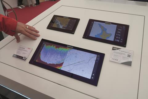
Launched at the beginning of 2024, Simrad’s new NSX Ultrawide aims to give the user a whole new viewing experience by combining several screens into one display. The main market is for pontoon boats, catamarans and small to midsize centre console boats that tend to have a wide but narrow dashboard. As such, the new display is 63% wider than existing NSX models and addresses the growing trend for a flushmounted display with a large graphics area. As demonstrated to IBI by Richard Jennings, Simrad’s UK-based service support engineer, the display not only offers incredibly sharp images for sonar and charts, it is also infinitely customisable. Several screens can be called up at once, pinched smaller, dragged to new positions, and manipulated as easily as the symbols on a mobile phone.
Boaters can also design a dashboard that is totally unique to them. The system sold in North America and Canada comes with bundled C-Map Discovery X Charts for those regions, and NSX is compatible with select third party chart options. Kevin Steinbraker, VP of the Navico Group that owns Simrad, said that ‘consumers have become used to – and love – the benefits of ultrawide screens. They can now have the same experience at the helm with immersive graphics and flexible viewing splits.’ The ultrawide aspect also allows boatbuilders to only fit one MFD, an advantage where space is tight.
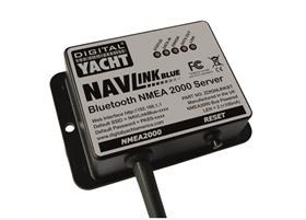
With more Bluetooth devices being brought aboard the average boat, hooking them up to the NMEA2000 backbone can be simplified by using a single connection and then the ability to receive signals from several devices at once. This is where the NAVlink Blue from Digital Yacht comes in.
The compact NMEA server is self-powered from the network. The company says it can be fitted in seconds and allows app developers for iOS and Android to use Bluetooth connectivity to utilise data available from the NMEA2000 backbone. The gateway is bi-directional, so Bluetooth sensor data can be communicated back into the system, allowing ‘an interesting range of 3rd party sensors to be connected and viewed’.
NAVlink Blue is said to be easy to pair with other Bluetooth devices, and to help app developers, the company publishes a software development kit (SDK) on their Github site. This opens raw NMEA2000 data to coders for third party development.

Advances in NMEA2000 connectivity Actisence’s new multiplexer
One of the greatest challenges as equipment evolves is connectivity. How do you make analogue ‘legacy’ equipment talk to the very latest digital kit, and how can you add domestic appliances to the same backbone? Luckily, several OEMs can assist and create a seamless network with the use of aftermarket gateways.
“Overcoming interconnectivity headaches and common challenges, such as bandwidth limitations, protocol mismatches and safe device isolation, has been a keen focus for our company,” says Justin Cohen, head of commercial operations for Actisence. The UK-based NMEA specialist has a solid track record of bringing out solutions that help both new boatbuilders as well as aftermarket users. A range of plug-and-play products help customers retain legacy equipment onboard, such as analogue engine instruments, while installing newer kit to run alongside it.
“Ahead of METSTRADE, we have released our latest innovation, which we believe is the ultimate solution for distribution of onboard navigation, safety and device data,” Cohen explains. “The Actisense PRO-NDC-1E2K brings together three major connectivity protocols: NMEA0183, NMEA2000 and high-speed ethernet, and with its certification by RINA, becomes the world’s first ever Type Approved multiplexer to include all three. This solves many of the interconnectivity challenges faced onboard, enabling highspeed data transfer for GPS, AIS, Autopilot and other onboard devices. The device simultaneously overcomes bandwidth limitations in a safe and pragmatic way. The thing that really sets this product apart is its user experience. The intuitive web-UI make it simple to use. Default configurations, flexible configuration on the go, autoswitching and sentence level filtering all allow for efficient management and greater control of instrument data. This makes it ideal for those who want to retain legacy equipment but also connect with modern NMEA2000 systems.”
The company says that the PRO-NDC-1E2K is part of the wider Actisense PRO range of Type Approved buffer and multiplexers. It features 5x NMEA0183 inputs, 2x NMEA0183 outputs, an NMEA2000 M12 connector and a copper ethernet connection. Also included is Actisense-i, describe as a powerful suite of diagnostic tools for NMEA2000 environments. The product will be featured on a live demonstration panel at the company’s stand at METSTRADE (Stand 01.603).
Seeking global recognition for leisure e-charts
The news that various hydrographic offices are planning to phase out paper charts in 2025 (now bumped to 2030 in the UK) came as no surprise to the marine industry, especially the commercial sector. Many would argue that electronic charts are far superior anyway, with the ability to automatically update over the internet and add extra layers of local pilotage information as required. However, the warning ‘not to be used for navigation’ persists. Instead, a global consensus is being sought to have a standard reference for all electronic charts, especially leisure versions, and one that is approved for use by the various regulatory authorities. A champion of this cause is the UK-based Royal Institute of Navigation (RIN) via its ‘Pleasure Vessel Navigation Systems Working Group’, abbreviated to WG. Comprised of highly experienced navigators, the Working Group has produced a series of suggested core standards for electronic charts and display systems. The report states these proposals are to ‘encourage suppliers to enhance eNavigation systems designed for small craft. The focus is on leisure vessels, with a view to moving towards recognition of such systems for navigation purposes’.
The WG feels that small craft, namely those under 24m, have specific requirements not currently met by ‘authorised’ electronic charts. In commercial shipping, Electronic Nautical Charts (ENCs) and Electronic Chart Display and Information Systems (ECDIS) have been mandatory since January 2011, but no small craft version exists. Current ECDIS charts are just too big for small craft use, and an attempt at a mini-ECDIS proved commercially unviable and never really took off. Instead, small craft must use special editions of electronic leisure charts sourced from various publishers, with the caveat they are a reference guide only, and not a primary source of navigation. The WG is trying to get that changed by setting international standards for uniform colours and symbols and asking chart publishers to get themselves accredited to a global system.
“Vessels below 24m LOA require more and better data than is available in official ENCs and thus on ECDIS equipment, particularly in shallow inshore waters or within marina infrastructure,” the WG says. “Such requirements are currently being met by unofficial ‘leisure’ charts which were core to our remit. Electronic navigation systems are now the ‘de facto’ main tool for navigating small craft, especially leisure vessels. However, most echarts and their display systems designed for leisure craft are currently unapproved and have a ‘Not to be used for navigation’ warning on starting up, which must be acknowledged before proceeding. However, e-charts are produced to a high standard of accuracy and designed for ease of use. The publishers have all emphasised the lengths they go to in providing a useful product for the small craft market, incorporating data from a wide variety of sources appropriate to the specific maritime area. We are not aware of any serious concerns over their quality or safety. Indeed, it is in the commercial interests of the publishers to strive to provide the best possible product from the information they have available. It is therefore considered imperative, in the interests of the safety of navigation of such vessels, to have a route for such currently unapproved systems to become recognised for primary navigation use. Specifically, we propose that electronic ‘leisure’ charts should not be subject to the ‘Not to be used for navigation’ constraint. This in turn will necessitate minimum (or core) standards for such echarts and display systems being set, and an officially recognised accreditation system being agreed.”
Further information, and a full copy of the report and proposals, can be found at rin.org.uk
Siri at sea?
With voice command for Siri or Alexa systems now common in smart homes and cars, we asked if the same technology was feasible on a boat? Most OEMs thought that the noise from wind, waves and motors would make it unfeasible, so had no plans to roll it out. The exception was Garmin. “We want to bring the same conveniences that our customers have at home or in the car to the boat,” says Garmin’s Dave Dunn. “We believe voice commands in marine electronics will grow in popularity.”
To get around the issues of ambient noise, Dunn says that communication is via either a Bluetooth body-worn microphone or the very popular Bluetooth earbuds. The dedicated receiver is connected to the MFD by NMEA2000 and interprets the commands.
“You prompt the receiver with ‘OK Garmin,” Dunn says. “Then we have a list of specific commands which can be slightly customised to suit your vocal style. Just like Siri or Alexa, the programme exits immediately after execution. So, if you say ‘OK Garmin, show sonar,’ the MFD will bring up the sonar screen, and then switch to standby until it hears the next ‘OK Garmin’ command.”
The potential for voice activation can stray well beyond just opening and closing displays. Soon, you may be able to say ‘OK Garmin, take me to the nearest port’ and the system will switch to an autonomous function and do the rest. Some existing systems will even dock the boat for you on arrival (except for the rope work, of course). Our only grumble is that, as with all voice command systems, there is no allowance for manners. Maybe OEMs can weave ‘please’ and ‘thank you’ into the prompts, rewarded with a ‘you’re welcome’ from the MFD?
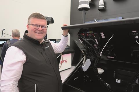
The installer’s view
With such a wide choice of brands and products, what helps to achieve a smooth sale and installation? Chris Rankmore, CEO of Platinum Marine, explains the trends.
An international specialist in navigation and audiovisual electronics is UK-based Platinum Marine, founded by experienced technician Chris Rankmore in 2010. The company has a full-time team of eight mobile installers, with an associate company, Quantum Marine, based in the UAE. With the UK headquarters close to Bournemouth Airport, Platimum’s engineers have quick and easy access to most of the Mediterranean, where they have a strong customer base. The company works closely with leading OEMs such as Sunseeker, Axopar and Azimut (UK) to install equipment at the new-build stage, and upgrade equipment during refits.
“We are installers for all the major brands such as Raymarine, Garmin, Simrad, B&G and Navico, so are completely unbiased when asked for a recommendation,” Rankmore explains. “We ask the customer what they had before, and if they had a good experience, we usually suggest they stay within that brand. Whatever the boatbuilder installed in a boat, the customer traditionally keeps, but that is starting to change.
“Most customers are expecting the boat to be as ‘smart’ as their house or car, with a centralised touchscreen display and the ability to remote access via an app. They usually want the screen as large as possible, flush-fitting and with the display going right to the edge of the glass. We have a team of designers and frame makers who can adapt modern MFDs to every type of dashboard. However, the owners of some classic boats are seeking retro styling, using existing instruments and having the MFD hidden away but still accessible. Others want their dashboard to look like something out of Star Trek.
“A lot of boat show visitors ask us if marine touchscreens are any good (they are) and some also like a separate keypad to be available, often mounted on the armrest of the command chair. Whatever they want, we will supply it.
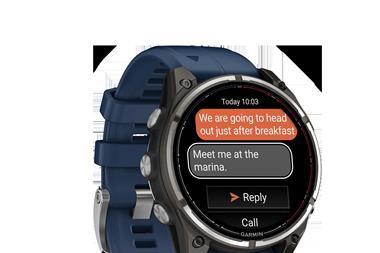
“We are certainly seeing a lot more interest in Garmin equipment, especially with new customers. We think this may be due to the use of this brand in other sectors, such as fitness and sports, with the Garmin watch now proving very popular.
The ease of N2K
“What is really helping with installations is the versatility of NMEA2000. Everyone wants their kit to be able to intercommunicate, along with the ability to add and control equipment from several different brands. N2K creates an open system, so everything from your Seakeeper stabiliser to your Schenker watermaker can plug in and be displayed on the MFD. In the UAE, for example, we are seeing a lot of emphasis on sustainability, with noisy gas engines banned in The Palm waterside residence. As a result, drop down hybrids such as that supplied by Blue Nav are proving very popular, and these also connect easily to the MFD by N2K.
“We offer training for customers with new kit onboard but find that touchscreen operations are very intuitive. The taps and swipes are based on the mainstream OEMs of Apple and Android devices. Gen Z, who now have the money to buy boats, understand the commands and menus almost instinctively. My son, for example, started using a smart watch when he was five.
Management software
Modern technology makes running our business a lot easier. We don’t need to hold much stock, as online ordering, most commonly from the Netherlands, is quick and easy. We run an app-based job management system called Service Mate, which allows us to centralise our customer notes and track our vehicles, so we know who is nearest to an urgent job. We can store specific notes and customer passwords in a central database and a full history of all the work we have done on a boat.
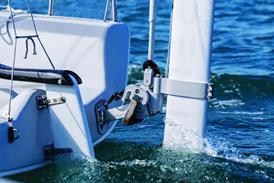
The rise of assisted docking
Volvo Penta was arguably the first to bring automatic docking into leisure marine with the use of pontoon mounted transponders and range-finding cameras. That was back in 2015, but others have since seen the advantages of greater spacial awareness when docking.
“NeuBoat Dock is proving very popular on larger boats, especially catamarans, where the skipper may be a long way inboard and surrounded by blind spots,” says Raymarine’s UK sales manager Richard Marsden.
The technology is already proven in self-parking cars which are fitted with LIDAR (Light Distance And Ranging – often laser based) sensors, and the imaging aspect has transferred easily to marine. The trickier bit has been linking the engines and thrusters to allow for full selfdocking, but the rise in electric propulsion, with its infinite increments in thrust, and the flexibility of Volvo’s independent drives, has made that easier.
The role of AI in pilotage
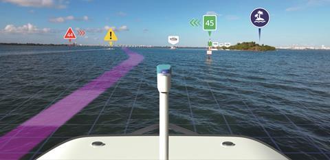
The ability to electronically probe the darkness and detect targets above and below the surface has been with us since the 1930s, but interpretation of the returns has largely been left to the operator. That is now changing as artificial intelligence and machine learning help make sense of the blips, blobs and – more recently – infrared images that are being fed back. Meanwhile, advanced thermal imaging systems created by the US-based FLIR, and which are viewable through the Raymarine Axion displays, are coming down in price and proving popular with cruising yachtsmen. “They like the idea of being able to spot floating debris and lobster pot markers at night,” Raymarine’s Richard Marsden explains.
Several OEMs are now harnessing the ability for AI to quickly reference an archive of preidentified images to work out if a target poses a potential threat. This has been critical to the development of autonomous ships, where a situation may develop quickly and need immediate action. Operators have realised that despite robust global connectivity systems like Inmarsat’s new NexusWave, they still may not always be able to log in remotely and take over. The ship must be able to think for itself.
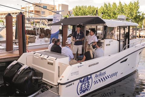
Recent arrivals on the AI-assisted sector have been Sea.AI, Avikus.ai and Lookout. Each harnesses the use of received images in a different way, but with the objective of giving the skipper as much useful information as possible.
One of the latest launches is Lookout, a US-based company that has created an ‘all-seeing’ AI camera system to help boaters navigate safely, especially at night. The website states that ‘Lookout synthesises data from charts, AIS, computer vision and the Cloud, and then fuses it into one intuitive 3D augmented reality view’. One of the main selling points is that the system remains right up-to-date, thanks to constant uploads with details of vacant docks, local wildlife, floating hazards and other navigation issues. The charts update automatically, and as the system learns, so it gradually gets better at identifying hazards afloat.
These systems aren’t cheap, starting at around US$13,000 for the Lookout, but when compared with the cost of repairing damage, or not taking the boat out because the visibility is too poor, it makes a wise investment to boating safety and pleasure.
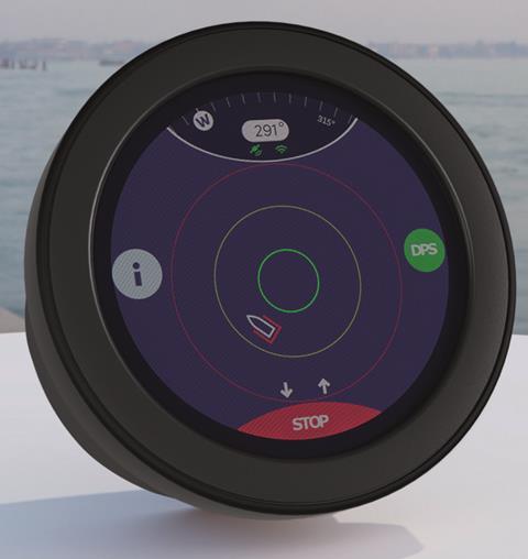
Holding station – dynamic positioning
An essential part of assisted docking, Dynamic Positioning Systems (DPS), is already widely used in the commercial shipping sector. Mercury Marine’s Skyhook was an early adopter in the leisure sector, and basically uses the boats engines and thrusters to hold an exact position on the water. This is usually in locations where the water is too deep to anchor, or where a boat needs to stay close to a feature or landmass. The DPS compensates for tide, wind and wave action that would otherwise quickly take a vessel off station.
The latest advance in DPS has come from Florida-based Dockmate, whose new DPS system won the 2024 Innovation Award in the Propulsion, Equipment and Parts category at the Miami Boat Show. Dockmate’s DPS is available in two modes – ‘Ocean’, allowing the yacht to hold a basic position so the skipper can ready ropes and fenders, and ‘Precision’, where the engines work with the thrusters to hold station at close quarters. The system is driven by an inertial measurement unit (IMU) which includes a compass, accelerometer and gyro, which connects to Dockmate’s GNSS antennas on the hardtop.
Looking ahead, precision station holding could emulate the methods used by electric service vessels who recharge via umbilicals from offshore wind farms. With many smaller deepwater wind and wave energy generators coming online (see IBI’s Pulse newsletter), DPS-equipped leisure craft would be able to safely recharge from them on passage with no risk of running into the infrastructure.
NeuBoat Dock is proving very popular on larger boats, especially catamarans, where the skipper may be a long way inboard
Conclusions
Sensors are getting better at seeing into the darkness, through fog, and deep underwater, presenting the operator with easily understood images and graphics. Wider, clearer screens are allowing for a high level of customisation by both the OEM and the user, and AI is being harnessed from the shipping sector to continue the drive towards full autonomouis navigation. At the same time, power requirements are increasing, so a boat is never completely turned off after use, needing supplemental power supplies from renewables, or a permanent connection to shore power. In the immediate term, most advances seem to be coming from software upgrades rather than from new hardware. What is clear is that with so much assistance available, and in the users of modern phones and computers will intuitively understand, a lot more people will be encouraged to buy a boat. They will realise that the electronics will take most of the stress out of navigating and, especially, docking, allowing them the freedom to fully enjoy their new boat.

 LinkedIn
 X / Twitter
 Facebook
 Email us