
Close menu
- Home
- Market Reports
- Product Reports
- News
- Companies
-
Topics
- Back to parent navigation item
- Topics
- Technology
- Browse all Technology >>>
-
Sustainability
- Back to parent navigation item
- Sustainability
- Boating industry comes together to develop Environmental Footprint Standard
- Custom sealing materials accelerate hydrogen roll out
- Is it a boat or plane? Could the Airfish herald a new mode of over water travel?
- Yamaha extends hydrogen competency with golf cart launch
- Browse all Sustainability >>>
- Marinas
- Browse all Marinas >>>
- Events
- Subscribe


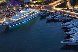
C-Map updates North American charts
By Craig Ritchie2025-03-03T15:19:00
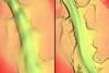
Improved shaded relief and high-resolution bathymetry add detail to coastal areas and more than 250 inland lakes
To continue reading this article…
Already registered?
Create a FREE account
To continue reading this article you must
register for a free account and login.
Subscribe to IBI Plus
Subscribe today and recieve
instant unlimited sitewide access.
- Subscribe
- Print Issues
- Topics A-Z
- Contact us
- Terms and Conditions
- Privacy Policy
- Cookie Policy
- © 2024 BOAT INTERNATIONAL MEDIA LTD.
 LinkedIn
 X / Twitter
 Facebook
 Email us
- Members of:
-
-
-
-
- Partners with:
-
-
- © 2025 Boat International Media Ltd.
- Topics A-Z
- IBI Magazine
- Terms & Conditions
- Privacy Policy
- Cookie Policy
- Subscribe
- Contact us
Site powered by Webvision Cloud